Summary
Plan an Inyo County fall color road trip from Lone Pine to Bishop, with seasonal timing and stops at Whitney Portal, Horseshoe Meadows, Onion Valley, Big Pine Canyon and Bishop Creek Canyon.
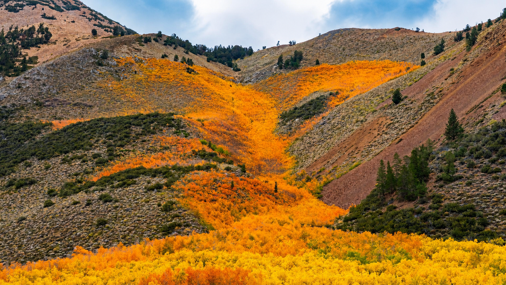
Every autumn, Inyo County’s mountain canyons, creek corridors and valley communities take on shades of lime, yellow, gold, orange, red and brown. Against the granite peaks and open landscapes of the Eastern Sierra, even a small grove of glowing aspens can transform the view.
One of the best ways to experience the season is on a road trip from Lone Pine to Bishop. US 395 connects communities across the Owens Valley, while scenic mountain roads climb west toward higher-elevation lakes, trails and aspen groves.
Along the way, travelers can explore Whitney Portal, Horseshoe Meadows, Onion Valley, Big Pine Canyon and Bishop Creek Canyon. The key is understanding the timing: fall color begins at higher elevations before gradually moving into lower canyons and the Owens Valley.
This is not a drive defined by one viewpoint or a single peak weekend. Fall color moves through Inyo County over several weeks, creating opportunities to follow the changing leaves from late September through October and, in some lower-elevation areas, into early November.
When Is the Best Time to See Fall Colors in Inyo County?
The primary fall-color season in Inyo County generally runs from late September through October. Cottonwoods and other lower-elevation trees may remain colorful into early November.
There is no single peak date for the entire county. Elevation, overnight temperatures, wind, moisture and sun exposure all affect when individual groves change.
Higher and colder locations usually turn first. The season then moves through middle elevations, lower canyons and, finally, the Owens Valley.
Late September to Early October: High-Elevation Color
Locations around 9,000 feet and above generally change first. These may include:
- Horseshoe Meadows
- Onion Valley
- Upper Big Pine Canyon
- South Lake
- Weir Pond
- Parcher’s Resort
- Lake Sabrina
- North Lake
These high-elevation destinations are also the most vulnerable to cold weather, strong wind and early snow. Their peak color can be brief.
Early to Mid-October: Upper and Middle Canyons
As October begins, fall color typically becomes more widespread between approximately 8,000 and 9,000 feet.
This period may bring changing leaves to:
- Whitney Portal
- Grays Meadow
- Middle portions of Big Pine Canyon
- Surveyor’s Meadow
- Mountain Glen Campground
- The groves above Bishop Creek Lodge
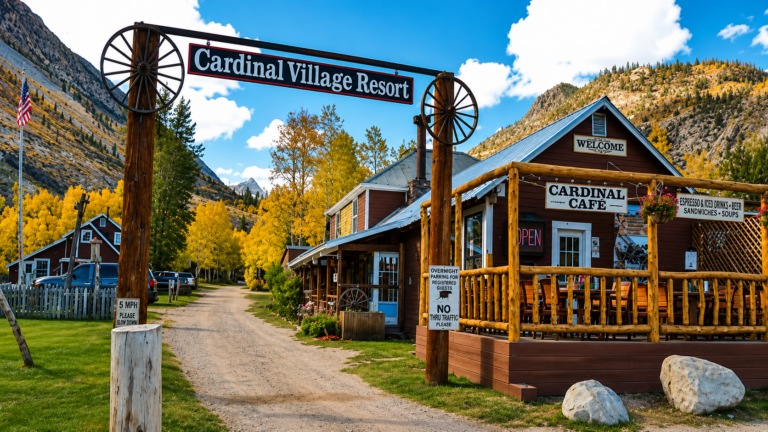
- Cardinal Village
- Intake II
- Four Jeffrey Campground
Individual groves can still change at different times. Color may be past peak at a sunny, exposed location while nearby trees in a protected area remain green.
Mid to Late October: Lower Canyons and Foothills
By the middle and latter portions of October, color generally moves into lower mountain canyons and foothill areas.
Look for changing leaves along:
- Lower Onion Valley Road
- Lower Big Pine Canyon
- Lower Bishop Creek Canyon
- Lower Pine Creek Canyon
- Round Valley
- Lower Rock Creek Road
This can be an especially productive period for a road trip because several lower and middle-elevation areas may be colorful at the same time.
Late October into Early November: Owens Valley Cottonwoods
Cottonwoods on the Owens Valley floor generally change later than high-elevation aspens.
Late-season color may appear around:
- Lone Pine
- Independence
- Big Pine
- Bishop
- The Owens River
- Buckley Ponds
- Rawson Ponds
- Local roads, ranchlands and agricultural areas
These timeframes are planning guides, not guaranteed peak dates. Temperature, moisture, wind and exposure influence when individual groves change and how long their leaves remain.
Warm weather may delay the transition. Cold nights can accelerate it. Strong wind or an early storm may strip exposed leaves quickly.
Before traveling, check the Visit Inyo Fall Color Tracker for observations from individual locations and elevations.
Why Do Leaves Change Color?
The shorter days and colder temperatures of autumn trigger changes inside deciduous trees.
Throughout spring and summer, leaves continually produce chlorophyll. This green pigment allows trees to absorb sunlight and make the nutrients they need to grow.
As the days become shorter, cells begin forming a barrier where each leaf meets its stem. Known as the abscission layer, it gradually restricts the movement of water and nutrients between the leaf and the tree.
Chlorophyll production slows, causing the green color to disappear. Other pigments then become visible. Xanthophylls create yellow tones, while carotenoids produce yellow and orange hues.
Red and purple colors come from anthocyanins, which are produced from sugars trapped inside certain leaves.
Weather influences the intensity and duration of fall color. Warm, sunny days followed by clear, cold nights can produce especially vivid leaves. Strong wind and early winter storms can quickly strip exposed trees.
Planning an Inyo County Fall Color Road Trip
US 395 forms the backbone of the route between Lone Pine and Bishop. From the highway, scenic side roads climb west from each community into the Eastern Sierra.
The four primary stops are:
Allow at least two days for the complete drive. A three-day itinerary provides more time for hiking, photography, local dining and changing plans based on current color.
Before entering the mountains, check road conditions, weather forecasts and public-land alerts. Conditions at a trailhead above 9,000 feet may be significantly colder than conditions along US 395.
Stop One: Fall in Lone Pine
Lone Pine combines high-elevation mountain scenery with the warm rock formations and open desert views of the Alabama Hills.
The three primary fall destinations are Whitney Portal, Horseshoe Meadows and the Alabama Hills. Each offers a different experience.
Whitney Portal
Whitney Portal Road climbs west from Lone Pine toward the base of Mount Whitney. The drive transitions from the open Owens Valley into a landscape of granite walls, evergreen forest and creekside vegetation.
Look for cottonwoods, willows and pockets of aspen around drainages, campgrounds and protected slopes. Fall color along this road is generally concentrated in small groves rather than spread across entire hillsides.
Whitney Portal sits at approximately 8,300 feet, so its leaves generally change before trees in Lone Pine and the Owens Valley. Temperatures can also be considerably colder than they are in town.
Services may be limited late in the season. Check road conditions and bring water, food and warm clothing before making the drive.
Horseshoe Meadows
Horseshoe Meadows Road climbs south and west of Lone Pine into a broad high-elevation landscape near 10,000 feet.
The drive offers expansive views across the Owens Valley before reaching forests, meadows and established trailheads. In autumn, visitors may encounter changing creekside vegetation, touches of gold among the trees and the seasonal browns of the open meadows.
Because Horseshoe Meadows is one of the highest stops on the road trip, it is also one of the first to experience cold autumn nights and early winter weather.
The area provides access to hiking routes, including trails toward Cottonwood Lakes. Anyone planning to hike should account for the elevation, shorter daylight and possibility of snow or ice.
Horseshoe Meadows Road is steep and winding. Confirm that it is open before leaving Lone Pine, drive carefully and stop only at established pullouts.
Alabama Hills
The Alabama Hills are not covered in aspens, but the area is especially beautiful in fall.
Cooler temperatures make walking and sightseeing more comfortable, while clear air and lower-angle sunlight bring out the warm colors and textures of the rounded rock formations. The Eastern Sierra rises sharply behind the rocks, creating one of the most distinctive views in Inyo County.
The Alabama Hills provide a scenic complement to the mountain color around Whitney Portal and Horseshoe Meadows. Their fall appeal comes from comfortable weather, changing light and the contrast between desert rocks and distant mountain vegetation.
Sunrise and late afternoon are particularly rewarding for photography. Use established roads, trails and parking areas, and avoid disturbing undeveloped ground.
Stop Two: Independence and Onion Valley
From Lone Pine, follow US 395 north to Independence. The community provides access to Onion Valley Road, one of the most dramatic elevation-based drives on the route.
The three principal areas to explore are lower Onion Valley Road, Grays Meadow and Onion Valley.
Lower Onion Valley Road
Market Street leads west from Independence and becomes Onion Valley Road. The route begins on the Owens Valley floor before climbing rapidly into the Eastern Sierra.
The lower portion of the road can provide later-season cottonwood and creekside color. Views back across Independence, the Owens Valley and the Inyo Mountains become more expansive as the road climbs.
Fall color may also appear around Independence after the high-elevation aspens have passed their peak.
Grays Meadow
Approximately six miles from Independence, Grays Meadow offers a leafy middle-elevation landscape along Independence Creek.
The creek, campgrounds and surrounding vegetation create an inviting autumn setting. Depending on the timing, visitors may see green, lime, yellow, gold and orange within the same area.
Because Grays Meadow sits below Onion Valley, it usually changes later than the upper trailhead. It can remain colorful after wind or cold weather has brought down leaves at higher elevations.
Onion Valley
Onion Valley Road continues climbing to just over 9,000 feet, gaining nearly 5,000 feet from Independence.
Aspens grow along creek corridors and protected mountain slopes, creating bright pockets of color against granite and evergreen forest. The elevation makes Onion Valley one of the earlier places to change.
At the end of the road, an established trailhead provides access to routes leading into the John Muir Wilderness and Kings Canyon National Park. Visitors can enjoy the setting on a short walk without committing to a long hike.
The route toward Kearsarge Pass is strenuous and reaches high elevations. Autumn hikers should begin early, carry warm layers and be prepared for rapidly changing conditions.
Allow at least two to three hours for a relaxed round trip from Independence, with more time if hiking.
Stop Three: Big Pine and Big Pine Canyon
Continue north on US 395 to Big Pine. Glacier Lodge Road follows Big Pine Creek west from town into the Eastern Sierra.
This portion of the road trip can be divided into lower Big Pine Creek, the scenic drive through Big Pine Canyon and the upper trailhead area.
Lower Big Pine Creek and the Owens Valley
Lower-elevation cottonwoods and willows grow around Big Pine Creek and throughout the surrounding Owens Valley.
These trees generally change later than the aspens farther up the canyon. They can provide fall color after the highest groves have lost their leaves.
The open valley also provides broad views of the Eastern Sierra. Even when color is limited, the clear air, cooler weather and changing light make autumn an excellent time to explore Big Pine.
Glacier Lodge Road and Big Pine Canyon
Glacier Lodge Road follows the creek west from Big Pine into a narrow mountain canyon.
Color often appears in ribbons along the water. Cottonwoods and willows are more common at lower elevations, while aspens become more prominent as the road climbs.
Creek crossings, campground areas and open bends provide views of golden foliage against evergreen forest and pale granite. Because the canyon includes several elevations and exposures, different sections may change at different times.
Drive slowly and use established parking areas. Avoid stopping in the travel lane, even when a colorful grove appears beside the road.
Upper Big Pine Canyon and the Trailheads
Near the upper end of Glacier Lodge Road, established trailheads provide access to the Big Pine Lakes area.
The upper canyon generally changes earlier than the lower road. Visitors do not need to complete a long hike to enjoy the setting; a shorter walk near the trailhead can provide creek views and a closer look at the foliage.
Routes leading farther into the Big Pine Lakes area are demanding wilderness hikes. Autumn hikers should begin early and prepare for cold temperatures, shorter days and possible ice.
Big Pine also provides access to the Ancient Bristlecone Pine Forest in the White Mountains. Bristlecone pines are evergreen rather than a source of traditional fall color, but their sculptural forms and high-desert surroundings are beautiful in clear autumn light. Because the drive is long and remote, plan it as a separate excursion.
Stop Four: Bishop and Bishop Creek Canyon
Bishop Creek Canyon contains the most concentrated collection of accessible fall-color locations on this road trip.
State Route 168 climbs west from Bishop before providing access to three mountain routes: the South Fork, Middle Fork and North Fork of Bishop Creek.
The upper lakes generally change first. Color then progresses through campgrounds, resorts and creekside groves before reaching Bishop and the Owens Valley.
South Fork of Bishop Creek
The South Fork leads toward South Lake and offers the longest sequence of fall-color locations in Bishop Creek Canyon.
Lower and middle-canyon reference points include:
- Four Jeffrey Campground
- The groves above Bishop Creek Lodge
- Mist Falls
- Mountain Glen Campground
- Table Mountain Campground
- Surveyor’s Meadow
- Willow Campground
Farther up the canyon, Parcher’s Resort sits among high-elevation aspens. Nearby Weir Pond is one of the most recognizable fall scenes in the area. When the water is calm, it may reflect yellow grass, colorful aspens, evergreen trees and surrounding peaks.
South Lake sits at approximately 9,768 feet. Its high elevation makes it one of the first Bishop Creek locations to change and one of the first to encounter winter conditions.
Middle Fork of Bishop Creek
The Middle Fork leads toward Lake Sabrina—pronounced “suh-BRY-nuh.”
Locations along the route include Big Trees Campground, Intake II, the groves above Cardinal Village and the approach to Lake Sabrina.
Intake II offers an accessible waterside setting surrounded by mountain vegetation. Higher on the road, Lake Sabrina combines aspens, willows, granite and open water.
At approximately 9,150 feet, Lake Sabrina generally changes earlier than lower Middle Fork destinations. After the upper leaves fall, color may remain around Cardinal Village, Intake II and lower portions of the road.
Mountain services can be seasonal, so visitors should arrive prepared even when the road is open.
North Fork of Bishop Creek
The North Fork climbs through Aspendell toward North Lake.
Aspendell can offer extensive fall color around the small mountain community. Above it, North Lake is known for aspens lining the water beneath the rugged peaks of the Eastern Sierra.
Because North Lake sits above 9,000 feet, it is among the first locations in Bishop Creek Canyon to change.
The final road is narrow and steep, with limited room to pass or turn around. Large vehicles and trailers are not recommended. Use designated parking and never stop in the roadway for photographs.
Late-Season Color Around Bishop
At approximately 4,150 feet, Bishop is much lower than the upper portions of Bishop Creek Canyon.
Cottonwoods around town, Buckley Ponds, Rawson Ponds and the broader Owens Valley generally change later than the high-elevation aspens. These areas can extend a fall-color trip into late October or early November.
North of Bishop, Round Valley and Lower Pine Creek Canyon offer additional middle- and lower-elevation possibilities. Lower Rock Creek Road can also hold color at a different time than the upper Bishop Creek destinations.
Suggested Two-Day Fall-Color Itinerary
Day One: Lone Pine, Independence and Big Pine
Begin the morning in the Alabama Hills, then choose Whitney Portal or Horseshoe Meadows based on current color and road conditions.
Continue north to Independence and drive Onion Valley Road. Stop at Grays Meadow before visiting the upper trailhead area.
Return to US 395 and continue to Big Pine. If daylight allows, explore lower Big Pine Creek or begin the drive into Big Pine Canyon. Stay overnight in Big Pine or Bishop.
Day Two: Big Pine Canyon and Bishop Creek Canyon
Begin with an early drive along Glacier Lodge Road into Big Pine Canyon.
Continue north to Bishop for food and supplies before entering Bishop Creek Canyon. Choose one primary fork based on current conditions:
- South Fork for the greatest number of roadside locations
- Middle Fork for Lake Sabrina and Intake II
- North Fork for Aspendell and North Lake
Return to Bishop before dark.
Suggested Three-Day Itinerary
A three-day itinerary creates a more relaxed road trip:
- Day one: Alabama Hills, Whitney Portal and Horseshoe Meadows near Lone Pine
- Day two: Onion Valley near Independence and Big Pine Canyon near Big Pine
- Day three: Bishop Creek Canyon and late-season color around Bishop
This schedule provides more time for short hikes, photography, local meals and changes caused by weather or shifting color.
Follow the Elevation, Not Just the Calendar
The best strategy for seeing fall color in Inyo County is to follow the elevation.
If the high-elevation aspens are still green, visit again later or explore another part of the county. If the upper groves have lost their leaves, move down the canyon. Middle and lower elevations may still be approaching peak color.
Think of the season as a wave moving downhill:
- High-elevation lakes, meadows and trailheads
- Upper and middle mountain canyons
- Lower canyons and foothills
- Owens Valley communities, waterways and agricultural areas
Check the Visit Inyo Fall Color Tracker shortly before leaving home and during the trip. Weather can change conditions quickly, especially at exposed high-elevation locations.
Fall Road Trip Safety
Conditions in the mountains may be very different from those along US 395. Before entering a canyon, review:
- Current fall-color observations
- Road closures and construction notices
- Weather at the destination’s elevation
- Public-land alerts and fire restrictions
- Seasonal campground and resort operations
Begin with a full tank of gas. Carry water, food, warm layers and an offline or paper map. Mobile service is unreliable in many mountain canyons.
Drive slowly and watch for wildlife, cyclists, pedestrians and ice on shaded pavement. Park only in established spaces and pullouts. If a viewpoint is full, continue to another safe location.
Responsible Leaf Peeping in Inyo County
Fall-color season brings additional traffic to narrow roads, small communities and sensitive natural areas.
Stay on established roads and trails. Do not walk through meadows or create informal paths into aspen groves. Keep private driveways, campground entrances and emergency routes clear.
Pack out all trash, including food scraps and pet waste. Secure food and scented items in bear country, and never feed or approach wildlife.
Follow posted leash rules and keep pets under control. Confirm that drone flights are permitted before launching, and avoid disturbing wildlife or other visitors.
Supporting restaurants, lodging properties, stores and service stations in Lone Pine, Independence, Big Pine and Bishop helps local communities benefit from fall visitation.
Frequently Asked Questions
What month is best for fall colors in Inyo County?
October is generally the primary fall-color month, but the season may begin at high elevations in late September. Cottonwoods in the Owens Valley can remain colorful into late October or early November.
Where does fall color begin first?
High-elevation locations generally change first. These include Horseshoe Meadows, Onion Valley, upper Big Pine Canyon, South Lake, Lake Sabrina and North Lake.
Where can I see late-season fall color?
For later color, explore lower canyon roads, Bishop, Big Pine, Independence, Lone Pine, Round Valley, local ponds and the Owens River corridor.
How long does the drive from Lone Pine to Bishop take?
The direct drive takes about an hour without stops. A complete fall-color road trip with mountain side trips is best planned over two or three days.
Where can I find current Inyo County fall-color conditions?
Check the Visit Inyo Fall Color Tracker for updates organized by destination and elevation. Road and weather conditions should also be confirmed before visiting mountain areas.
Do I need to hike to see fall colors?
No. Many of Inyo County’s fall-color locations can be viewed along scenic roads or near established parking areas. Hiking provides additional perspectives but is not required.
Follow Fall Color from Lone Pine to Bishop
An Inyo County fall color road trip reveals autumn as a progression through elevation and landscape.
Horseshoe Meadows and Onion Valley introduce the season at high elevations. Whitney Portal, Grays Meadow and Big Pine Canyon bring color into the mountain corridors. Bishop Creek Canyon offers several branches to explore before cottonwoods complete the season across the Owens Valley.
Come prepared, follow current conditions and remain flexible. Inyo County’s fall color is not limited to one famous view or one perfect weekend. It moves through the canyons, waterways and communities of the Eastern Sierra, creating new reasons to explore throughout the season.